Data Development
To promote the development and accessibility of GIS data in Missouri
Mission:
The committee’s focus is to assess the geospatial data needs in the state of Missouri, develop plans of action to meet those needs, and work to ensure that the data meets those needs. The data development subcommittee is committed to making all geospatial data discoverable and available to the general public through the State’s spatial data clearinghouse.
Background:
The Data Development subcommittee is primarily concerned with the framework data themes as defined by Federal Geographic Data Committee (FGDC), and by the MGISAC. The federal data themes include: Orthoimagery, Elevation, Cadastral, Transportation, Hydrography, Administrative Boundaries, and Geodetic Control. The Missouri data themes include Geology, Land Cover, Soils, and Critical Infrastructure.
To encourage the development and maintenance of the geospatial data, the subcommittee will identify and support data stewards for those framework data themes and seek opportunities for partnerships to advance and sustain these efforts.
The Data Development subcommittee held its first meeting on July 8, 2008 to facilitate discussions about data development efforts and data needs. The subcommittee successfully engaged partners to acquire two-foot resolution leaf-off imagery for the eastern side of Missouri in 2007, and will acquire imagery for the remainder of the state in 2008. The 2008 flight includes buy-up options for higher resolution imagery for cities, counties, and regional planning organizations.
Team Members
| Buster Schrage, City of Jefferson (Chair) | Shawn Penman |
| Tim Bixler | Katie Philbrick |
| Jacob Goldman | Jerry Prewett |
| Wiley Howell | Tracy Schloss |
| Nathan Mattox | Reid Veigut |
| Brian Maydwell | Thomas Vought |
| David Nail |
Statewide Imagery Project![]()
The state contract has been designed for local government; contractors have been pre-qualified allowing state and local government to obtain bids from each contractor without having to go through the Request for Proposals (RFP) process. For details please visit www.flymoimagery.com
March 7, 2023 Webinar Recording
Webinar Recording
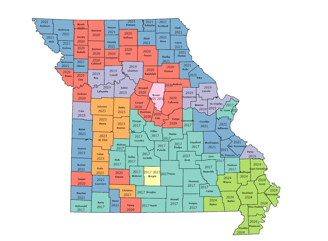
LiDAR Status in Missouri
LiDAR and Elevation Derived Hydrography Project Dashboard
Missouri LiDAR Acquisition by County, 3/25/2024