GIS Mapping Helps Citizens Find Health Services in Their Area

GIS mapping for the Department of Health and Senior Services is used effectively to show Missourians what health services are available in their area. GIS was originally used to generate paper maps and export basic PDFs. Like many other GIS shops, the original Internet maps were based on ESRIs product, ArcIMS. As ArcIMS became dated, the GIS staff started looking around for alternatives. When the FLEX API came available, it moved to the top of the list. (FLEX is an Adobe programming language.) This API allows GIS staff to continue to develop data within the ESRI suite of products and offers a whole new set of components within the FLEX environment.
The first Internet map in this new environment was for Women, Infants and Children (WIC), a program that provides supplemental nutrition to pregnant women, new mothers, infants and children up to their 5
th birthday. Not only are there WIC offices and satellites across the state, but hundreds of grocery stores accept the WIC coupons.The data was posted on web pages, and each county was shown as a list of sites. But how could you tell which ones were closest to you? The answer, of course, was to provide the information in the form of an interactive map.
The WIC interactive map went live in October of 2009. One of the challenges in posting information to the web is to keep the information up to date. So not only was the map interface created, but a data update process and interval was devised. WIC staff regularly updates the underlying data set, which is stored in a simple Access database. Since the sites are represented as points on the map, the latitude and longitude are stored as part of it. As new sites are added, WIC adds all the site information and the GIS staff comes along behind and populates the latitude and longitude. This rather basic process works for both staff, WIC didnt have to learn much GIS and the GIS staff only have to fill in a few missing coordinates. The data set is updated on a monthly basis.
Not only was it immediately an easier to use interface than the previous ArcIMS version, but it marked a renewed interest in Internet mapping throughout the department. Over the next year and a half, this first WIC map has become the template for many other subjects. Some programs, like WIC, only populate a basic table. Others, like the flu vaccine clinics and the summer food programs, connect directly to production data that are populated from other applications.
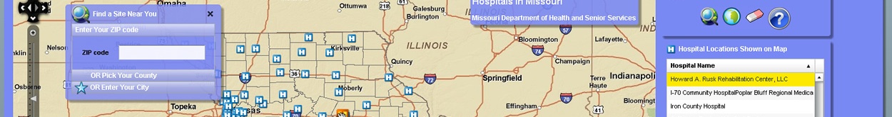
A complete list of interactive maps can be found at http://dhss.mo.gov/data/gis/index.php. Currently interactive maps are available for cooling centers, state lab courier sites, hospitals, federally qualified health centers and rural clinics (listed as Health Facilities), WIC services, asthma hospitalization rates, carbon monoxide poisoning rates, rates of childhood blood lead testing and vaccine flu clinic sites. Some sites are more seasonal, such as cooling centers, and may not always be available.